 | ||||||
|
|
|
|
|
||
| ||||||
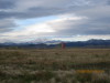
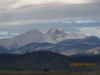
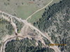
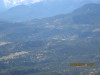
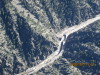
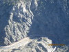
| Silo on the prairie, with Longs Peak in the background, 10/05/13. | Closeup of Longs Peak, 10/05/13. | Ranch on the Middle St. Vrain drainage, NE of Lyons, CO. White stones on the riverbed say "We (Heart) MUD", 1, 10/08/13. | Ranch on the Middle St. Vrain drainage, NE of Lyons, CO. White stones on the riverbed say "We (Heart) MUD", 2, 10/08/13. | Washout on US36, 2 mi NW of Lyons, CO, 10/08/13. | ||
| ||||||
|
|
|
|
|
||
| ||||||
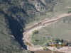
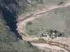
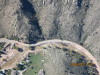
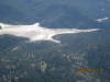
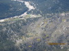
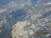
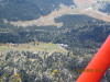
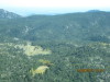
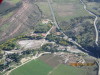
| The flood brought a lot of muddy water into the Coffin-top Reservoir. The Coffin-top Reservoir is located on the South St. Vrain Creek approximately 1.6 kilometers southwest of the town of Lyons, Colorado, 10/08/13. | Washout on US36, NW of Lyons, CO, 10/08/13. | US36 NW of Pinewood Springs, looking E at the turnoff for the Camp in the next picture, 10/08/13. | Camp NW of Pinewood Springs, W of US36. The access road is washed out for 3 miles downstream to US36, 10/08/13. | Elk Park Airport Hangar is visible at the lower left, looking SW, 10/08/13. | ||
| ||||||
|
|
|
|
|
||
| ||||||
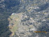
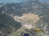
| Elk Park Airport is dry and usable, 1, 10/08/13. | Elk Park Airport is dry and usable, 2, 10/08/13. | Elk Park Airport, looking S, 10/08/13. | Alluvial fan on the E side of Twin Sisters, looking NW, 1 mi NW of Elk Park Airport, 10/08/13. | Elk Park runway, looking E toward the plains. The Camp a few pictures back is located downstream left of the rock at mid-picture, left of the runway centerline, 10/08/13. | ||
| ||||
|
|
|
||
| ||||
| US34, looking SW at the diversion structure just above the Narrows, 10/08/13. | US34, 2 lane gravel road is reconstructed from the Dam Store site about 1 mile upstream, 10/08/13. | Big Thompson siphon across US34 is at bottom right. Center frame, looking SSE is what is left of Sylvan Dale Ranch and Convention Center, 10/08/13. | ||