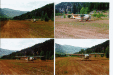
2002-09-21-Marble-N182: Marble, Colorado, private airport, used with permission.
Back to parent gallery
> Subject: CPA Mtn Flying Course, Marble fly-in, Dolores Point Airport in CO
> To: coloradoflying@airbase1.com
Msg #: 1
Subject: RESCHEDULED: Marble Airstrip Fly-in & CPA Mtn Flying Course
From: sales@airbase1.com
Msg #: 2
Subject: Re: RESCHEDULED: Marble Airstrip Fly-in & CPA Mtn Flying Course
From: wmeine@mindspring.com
###################################
##
## Msg #: 1
## Subject: RESCHEDULED: Marble Airstrip Fly-in & CPA Mtn Flying Course
## From: sales@airbase1.com
##
###################################
Subject: CPA mountain flying course
Please see the URL at:
http://coloradopilotsassociation.org/
Due to conflicting calendars, the Marble, Colorado grass airstrip fly-in
will now be held September 21 and 22, 2002. This also happens to be the
dates of the Wine Tasting Festival in nearby Grand Junction. This
fly-in date was selected as the week after the renowned (!) Colorado
Pilots Association Mountain Flying Course, with September 14 for ground
school, and an (optional) flying day with CPA instructors on September
15. This allows one to get familiar with the airstrip with an
instructor on board the week before you take your family. Be sure to
re-mark your calendars!
Details and registration forms for the CPA course will be available at
www.ColoradoPilots.org website. The course will be given at Strand
Flying on the Grand Junction Walker field (www.strandflying.com).
Additional airstrips will be determined for the 9/15 "flying day" -
maybe some in nearby Utah???
You will not be required to take the CPA course, but the Marble airstrip
is NOT for inexperienced pilots. It is a privately owned grass runway
within a canyon. Prior permission from the owner, Bob Conger, is
desired, and all operations are at pilot's own risk. Bob will grant
permission freely and I will coordinate this as the time nears and send
out "Hold Harmless" forms for all participants. Bob last was a Maule
driver, but even Aztecs have used the strip. Bob wants more airplanes
to visit him and share his piece of Colorado Rockies paradise!
Marble is the site of an old marble quarry (duh) that provided the
stones for many Washington DC monuments. A tour is available and the
town is just a couple of miles down the road from the airstrip. The
airstrip is 3800 feet of meticulously manicured lawn at 7800 MSL. Due
to terrain, landings are generally made to the east and takeoffs to the
west. It will not be found on any sectional, but is located just east
of McClure pass at N39.04'30" - W 107.12'50". Fair fishing and good
camping.
Paonia airport and nearby facilities will be used for those who want to
sleep in a real bed, or who would like to have an experienced instructor
pilot join them in their aircraft for the ten minute flight into the
Marble landing strip.
See you there!
Rob Duncan
###################################
##
## Msg #: 2
## Subject: Re: RESCHEDULED: Marble Airstrip Fly-in & CPA Mtn Flying Course
## From: wmeine@mindspring.com
##
###################################
Rob Duncan wrote:
> Additional airstrips will be determined for the 9/15
> "flying day" - maybe some in nearby Utah, Karl???
The Utah folks have always considered Dolores Point to be one of their
own but it is, in fact, a Colorado backcountry airstrip. It is on top
of a mesa just northwest of Gateway overlooking the Dolores River. The
strip is in immaculate condition because it is dragged several times per
year by a Gateway resident with a love of aviation. The Utah Back
Country Pilots have had a couple of fly-ins there and many wheel-panted
182s have used the runway with no problems. There are dimly visible Xs
on the runway from 1992 which can be ignored (made with lime and just
won't wash away). It is BLM land and both the use of the airstrip and
camping are allowed by normal BLM rules. Although over 3300 feet of
length was carved out of the sage brush, visibility concerns (due to
three hills on the southern half) and current maintenance make the
practical length about 2400 feet. The runway slopes uphill to the
south. Most people land to the south and take off north when conditions
allow. There is a large circular parking area with room for many planes
near the southern end. Dolores Point is truely a spectacular
destination for those pilots qualified to land there.
Latitude and longitude: N 38 42.201, W 109 02.621
Elevation (ft): 7120
Radio frequency: 122.9
Windsock: No
OK to camp: Yes
Runway length (ft): 2400 x 75
Runway surface: Dirt/Grass
Runway orientation: 14-32
Enjoy,
-Bill
================================================================
For further information, including unsubscribe instructions, see
http://www.airbase1.com/coloradoflying/quickhelp.htm
Be considerate. Most subscribers do not want to see any personal
replies. For personal replies, change the "To:" address or click
here->> mailto: (for a new mail window)
================================================================
N182H, Cessna 182 at Marble, Colorado, after landing, looking West.
N182H, Cessna 182 at Marble, Colorado, taking off, looking East.
marble-airport.txt
created with
llgal